1
Copyright © 2017 Allianz Global Corporate & Specialty SE (All rights reserved)
Rencontres 2019
LES NOUVELLES TECHNOLOGIES AU SERVICE DE LA
GESTION DES SINISTRES ASSURABLES (A9)
1
27
èmes
Rencontres du Risk Management AMRAE
Jeudi 7 février – 9h-10h30
2
Copyright © 2017 Allianz Global Corporate & Specialty SE (All rights reserved)
Rencontres 2019
2
3
Copyright © 2017 Allianz Global Corporate & Specialty SE (All rights reserved)
Rencontres 2019
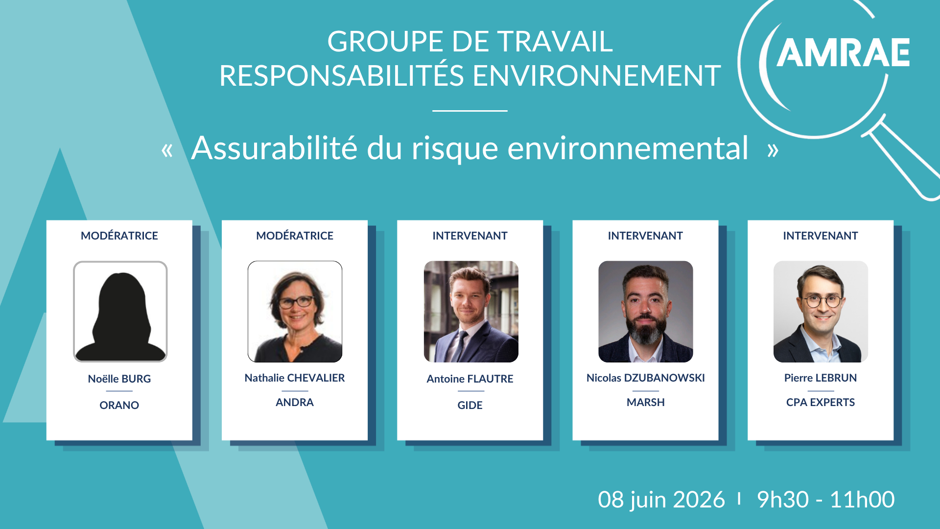
PRÉSENTATION
3
Intervenants
Modérateur
Philippe Donaint
Directeur général de TEXA GLOBAL
SOLUTIONS, Group Stelliant
Anne Urdiroz
Chargée d'affaires au sein de
TRE ALTAMIRA
Christopher ScheldonHead of Claims and New
Technologies Ideation, AGCS
Michel Josset
Faurecia
Directeur des Assurances,
de la Prévention et de l’Immobilier
4
Copyright © 2017 Allianz Global Corporate & Specialty SE (All rights reserved)
Rencontres 2019
AGENDA
Introduction, présentation des intervenants - 5min,
La digitalisation au service de la gestion des sinist res dommages:
C. Sheldon (Allianz) , P. Donaint (Texa) - 45 min
Application à la gestion de sinistres de la technologie de détection de
mouvements du sol par images satellite radar :
Anne Urdiroz, Tre Altamira - 20 min
Démonstration de la plate forme digitale Digisinistre pour la gestion de
sinistres simples :
P. Donaint, Texa - 10 min
Conclusions, questions - 15 min
4
CLAIMS & NEW
TECHNOLOGIES
IDEATION:
DIGITALLY ENHANCED
CLAIMS HANDLING
Allianz Global Corporate & Specialty SE
5
Copyright © 2017 Allianz Global Corporate & Specialty SE (All rights reserved) 12-Feb-196 TODAY WE HAVE TO THINK INNOVATIVELY, THINK BIG,
THINK DIFFERENTLY, AND THINK OUTSIDEOF THE BOX
7
© Copyright Allianz SE 12.02.2019
Claims & New Technologies Ideation Workshop 1.0
7
8
Copyright © 2017 Allianz Global Corporate & Specialty SE (All rights reserved)
Drones Services & Cloud Information Platform
Quicker assessment of outdoor risks/claims
Cheaper and quicker assessment of roof
damage
View damage at Nat Cat location before
human can
Benefits for Risk Managers
1
Roof damage
Hail storms
Wild fire
Flood
Earthquake
Explosions and
fires
What Kind of Claims
2
Claims that only have outdoor damage
Roof inspections
Flood analysis
Damage inspections of buildings after
earthquake
Hurricane damage inspections
To fully pay out hail damaged roof claims
Can be Used in
3
DRONE FLIGHTS FLOWN GLOBALLY
Denver Hail Storms
Hurricane Harvey
9
Copyright © 2017 Allianz Global Corporate & Specialty SE (All rights reserved)
Drones Services & Cloud Information Platform
We use drones on a regular basis.
They allow us to:
Save time when observing
damage to large roofs, taking
stock of multiple sites and
accessing weakened roofs or
other hard-to-reach areas,
Access collapsed buildings with
ground-based drones,
Present the case to the
participants without having to
travel,
Preserve information without
having to go back to the site,
Additionally, they ensure the
safety of all of the participants,
Future potential: combining
drones with image recognition,
modelling and costing software.
Philippe Donaint: adjusters view
DRONE FLIGHTS FLOWN GLOBALLY
Denver Hail Storms
Hurricane Harvey
10
Copyright © 2017 Allianz Global Corporate & Specialty SE (All rights reserved)
DIGITAL DEFENCE LAWYER TOOLKIT
PILOTED IN UK LIABILITY CLAIMS DEPARTMENT:
ENABLED US NOT TO INSTRUCT LAWYERS
Save money on lawyer costs
Create legal documents quicker than using
outside lawyers
Empower staff to undertake legal work tat
they did not previously do
Benefits for Risk Managers
1
Liability
Aviation liability
Marine liability
MidCorp
Subrogation
What Kind of Claims
2
Hi-low claims
Mid-level claims
Simple claims
Litigations up to any hearing
Can be Used in
3
The Allianz Digital
Lawyer Tool Kit:
11
Copyright © 2017 Allianz Global Corporate & Specialty SE (All rights reserved)
DIGITAL DEFENCE LAWYER TOOLKIT
PILOTED IN UK LIABILITY CLAIMS DEPARTMENT:
ENABLED US NOT TO INSTRUCT LAWYERS
ARTIFICIAL INTELLIGENCE TO
COURT-APPRAISED FILES
Text recognition has been around
for a long time. Whats new,
however, is the addition of an
automated feature (AI) to accelerate
processing, orientation,
qualification...
We use it to sort through incoming
e-mails. This is essentially a
process improvement, allowing us
to accelerate file treatment while
increasing reliability. It frees up time
for other things. And we all know
loss adjusters never have enough
time.
MODELLING
Were seeing the use of a lot of
decision trees/models, and were
using them too. Aside from just the
feedback from our assignments,
weve also created various models
to help us identify root causes.
This helps loss adjusters make their
decisions.
Philippe Donaint: adjusters view
The Allianz Digital
Lawyer Tool Kit:
12
Copyright © 2017 Allianz Global Corporate & Specialty SE (All rights reserved)
LIVE STREAM CLAIMS APP AND
DIGITAL MEDIA HUB
AN OVERVIEW OF THE NEW CLAIMS TECHNOLOGY
Benefits for Risk Managers
1
Our aim was to create something simple and easy to use
Using hardware that everyone already uses day-to-day
Smart Phone App
Live Stream Adjusting
Property
Engineering
Energy
MidCorp
Liability
Aviation
Marine
Entertainment
CrisisManagement
EIL
Others
?
What Kind of Claims
2
For all virtual risk assessments
In all claims situations
Taking evidence and storing of it in case of a
future dispute
To document health and safety
Can Be Used In
3
Notification to your phone as a claim is
happening
Digital media collection and storage
Desk-top adjustment of small claims
Receive from your insurer instant loss
advice, assessment and mitigation on large
claims
Virtual video visit of site visit when
appropriate
13
Copyright © 2017 Allianz Global Corporate & Specialty SE (All rights reserved)
LIVE STREAM CLAIMS APP AND
DIGITAL MEDIA HUB
AN OVERVIEW OF THE NEW CLAIMS TECHNOLOGY
Philippe Donaint: adjusters view
Our aim was to create something simple and easy to use
Using hardware that everyone already uses day-to-day
Smart Phone App
Live Stream Adjusting
Its already a standard tool which
we use regularly. What is more
interesting is its potential: used
in conjunction with custom AI,
video tools can use smart image
recognition to conduct a virtual
costing.
It is, for example, what were
developing with STELLIANT with
the DIGICLAIMS tools. Automatic
costing for simple losses is
already operational, and is
already being combined with
video and image recognition.
14
Copyright © 2017 Allianz Global Corporate & Specialty SE (All rights reserved) CLAIMS ARC INFRARED THERMOGRAPHY INITIATIVE
Receive payment for claims you did not know
you had
Faster claim inspections
Accelerate water damage assessment and
reduce the potential for missing affected areas
Providing evidence of construction defects
Benefits for Risk Managers
1
Property
Engineering
Liability
Inland Marine
MidCorp
What Kind of Claims
2
Turbine claims
Transformer claims
Solar panel claims
Electrical claims
Water damage claims
Can be Used in
3
Pipe Damage
Electrical Damage
Water Damage
Roof Damage
Calgary Floods 2017
15
Copyright © 2017 Allianz Global Corporate & Specialty SE (All rights reserved) CLAIMS ARC INFRARED THERMOGRAPHY INITIATIVE
These are great tools, and are part
of the basic kit we provide to our
loss adjusters!
Philippe Donaint: adjusters view
Pipe Damage
Electrical Damage
Water Damage
Roof Damage
Calgary Floods 2017
16
Copyright © 2017 Allianz Global Corporate & Specialty SE (All rights reserved)SATELLITE IMAGERY ANALYTICS: TRANSFORMING
INSURANCE THROUGH AERIAL INSIGHT
View any of your locations from your desk
During Nat Cat event view situation as it
develops at your insured location
Hurricane: plan and instigate measures to
mitigate business interruption before
employees have returned to facility
Benefits for Risk Managers
1
Property
Engineering
Inland Marine
MidCorp
What Kind of Claims
2
Hurricane
Wild fire
Flood
Earthquake
Can be Used in
3
INat Cat Response : assess damage to insured locations in real time during and immediately after a Nat
Cat event: with AI reserving estimates within 24 hours. View damage from your desk via secure web
portal.
IClaims Adjustment : direct loss adjusters, inform insureds, start loss mitigation measures, receive AI
property loss value estimations, BI/CBI predictions and enable STP payments.
Hurricane Florence:
event response
flood mapping
Hurricane Harvey:
Damage Assessment
17
Copyright © 2017 Allianz Global Corporate & Specialty SE (All rights reserved)SATELLITE IMAGERY ANALYTICS: TRANSFORMING
INSURANCE THROUGH AERIAL INSIGHT
Were currently experimenting
with this tool, alongside
companies such as VisioTerra.
There are two key advantages
about this:
Large-scale: we can make an
initial judgement from an aerial
view. This can give us a good
overview of structural damage.
Where it can be more useful,
however, is when buildings have
been completely destroyed and
we have a prior valuation of the
contents. We can take a satellite
image to estimate the total
damage without having to send in
any loss adjuster.
Although, clearly, this will only
apply to a few cases.
Additionally, this is less useful for
complex technical risks than to
relatively simple individual ones.
Philippe Donaint: adjusters view
Nat Cat Response : assess damage to insured locations in real time during and immediately after a Nat
Cat event: with AI reserving estimates within 24 hours. View damage from your desk via secure web
portal.
Claims Adjustment : direct loss adjusters, inform insureds, start loss mitigation measures, receive AI
property loss value estimations, BI/CBI predictions and enable STP payments.
Hurricane Florence:
event response
flood mapping
Hurricane Harvey:
Damage Assessment
18
Copyright © 2017 Allianz Global Corporate & Specialty SE (All rights reserved)
Imagery
Any document or file type
Automation Workflow
Permissions
Structure
TemplatingClient-
Configurable
BI/MI including
Unstructured Data
Any Claim Participant
Imagery
Any document or file type
Automation Workflow
Permissions
Structure
TemplatingClient-
Configurable
BI/MI including
Unstructured Data
Smartphone Tablet PC/Laptop
Imagery
Any document or file type
Automation
Workflow Permissions
Structure
Templating Client-
Configurable
BI/MI including
Unstructured Data
Insurer
One single digital record
Imagery
Any document or file type
DIGITAL COLLABORATION PLATFORM
Global Collaboration Platform :
Delivers a Net Promoter
Score (NPS) of 76
Small claim withdrawals
over 35%
Customer satisfaction at
9.8/10
Mid complexity claim
withdrawals 7%
Indemnity cost reduction 17%
24/7/365 service. Earliest
visit 05:58 hrs. Latest 22:50
hrs
Major UK Insurer gross
savingsof EUR 30m pa
Cycle times reduced by
50%. Enable decisions on
day 1
Allianz UK : Our Customer and Broker feedback is
very good, with positive comments received in an
embedded customer satisfaction survey, about the
ease of use and intuitive nature of the customer
journey (all locally configured and managed). We
recently moved our motor journey from a competing
digital media capture platform (VueCloud) onto the
SiteView system and instantly started to receive
positive feedback from Brokers on the change.
(4000 claims processed)
19
Copyright © 2017 Allianz Global Corporate & Specialty SE (All rights reserved)
Imagery
Any document or file type
Automation Workflow
Permissions
Structure
TemplatingClient-
Configurable
BI/MI including
Unstructured Data
Any Claim Participant
Imagery
Any document or file type
Automation Workflow
Permissions
Structure
TemplatingClient-
Configurable
BI/MI including
Unstructured Data
Smartphone Tablet PC/Laptop
Imagery
Any document or file type
Automation
Workflow Permissions
Structure
Templating Client-
Configurable
BI/MI including
Unstructured Data
Insurer
One single digital record
Imagery
Any document or file type
DIGITAL COLLABORATION PLATFORM
Philippe Donaint: adjusters view The digital platform allows us to
give clients a 100 % end-to-end
digital experience, which
combines all of the technology
weve seen up to now: robotics,
chatbot, AI, video, etc. This has
become standard, even though
100% digital systems remain very
much the minority. Clients still
appreciate working directly with
actual people.
Of course, this applies mainly to
private losses or smaller direct-
damage type losses. It allows
loss adjusters to focus on more
complex issues rather than
minor losses, and of course,
there are advantages for the
client (see NPS 76). I talked about
DIGICLAIMS, which is an example
of a digital system with an NPS of
more than 80 %.
20
Copyright © 2017 Allianz Global Corporate & Specialty SE (All rights reserved)
File name | Department | Author
12-Feb-19 Three
intents
discussed:
Obtaining contact details
Submitting a claim
Getting a claim status
Policy
and
claims referencing
logic used to identify the
AGCS office and the line of business
Database of claims handlers with details of their locati on and
line of business focus
Information entered by the user analysed by the bot and
emailed to the appropriate claims handler
Bot built with
Skype integration
for use on
multiple
platforms
(PC, mobile, tablet).
AGCS CLAIMS CHATBOT
DEVELOPMENT OF PROOF OF CONCEPT
AGCS Claims Chatbot
21
Copyright © 2017 Allianz Global Corporate & Specialty SE (All rights reserved)
File name | Department | Author
12-Feb-19 Three
intents
discussed:
Obtaining contact details
Submitting a claim
Getting a claim status
Policy
and
claims referencing
logic used
to identify the AGCS office and the line of
business
Database of claims handlers with details of
their location and line of business focus
Information entered by the user analysed by
the bot and emailed to the appropriate
claims handler
Bot built with
Skype integration
for use on
multiple platforms
(PC, mobile, tablet).
AGCS CLAIMS CHATBOT DEVELOPMENT OF PROOF OF CONCEPT
AGCS Claims Chatbot
Philippe Donaint: adjusters view Callbots and chatbots can be
used to set up a simple FAQ
(Frequently Asked Questions),
although some take the idea a
little further. It means the loss
adjuster or the assistant doesnt
have to field the most common
questions. And the client has an
immediate answer to their
question as a chat or voice call.
With STELLIANT, were currently
rolling out callbots to help out the
Client Services space with the
most commonly asked questions.
This includes, for example, the
documents to prepare, when the
loss adjuster is scheduled, when
the report will be ready and other
questions.
AGCS Global Claims | October, 2018
22
CLAIMS AND DIGITILISATION AT AGCSIN 2019
Using
data datadata data
, statistical , statistical , statistical , statistical
algorithms algorithms algorithms algorithms
, , , ,
machine learning machine learning machine learning machine learning
,,,,
AAAA
rtificial rtificial rtificial rtificial
IIII
ntelligence ntelligence ntelligence ntelligence
and and and and
analytics analytics analytics analytics
we
want to identify the
likelihood of future
outcomes in order to
augment and augment and augment and augment and
accelerate business accelerate business accelerate business accelerate business
decision decision decision decision----making making making making
AGCS Global Claims | October, 2018
23
CLAIMS AND DIGITILISATION AT AGCSIN 2019
Philippe Donaint: adjusters view BIG DATA OR DATA MINING
Clearly, loss adjusting firms are
sitting on a vast trove of data. It
makes sense to use these in two
ways:
If you take and analyse factory fire
data over the past 20 years, you can
identify patterns and causal models
which can help the loss adjuster
better analyse future losses. This is
what companies such as
MondoBrain are doing.
At the same time, this knowledge
can be used to predict losses before
they happen.
DATA ANALYSIS FOR A FRAUD CASE
This is almost a classic by now.
Companies such as Shift
Technology offer cross-sector
analysis. This is more relevant for
insurers than for loss adjusters, as
they can quickly amortise the costs
of these analyses.
DÉTECTIONDE MOUVEMENTSDU SOL À PARTIR D’IMAGES
SATELLITESRADAR
INFORMATION FROM SPACE
25
PRÉSENTATION TRE ALTAMIRA GROUPE CLS
Actionnariat Groupe CLS
53,91%
31,73%
14,11%
0,25%
26
PRÉSENTATION TRE ALTAMIRA GROUPE CLS
Leader en Interférométrie radar
TRE ALTAMIRA: Leader mondial dans la mesure
millimétrique de mouvement du sol à partir dimages sa tellite radar
27
PRÉSENTATION TRE ALTAMIRA GROUPE CLS
Les secteurs dactivité
Pétrole et gaz Institutionnel Infrastructures Mines
-
Gestion et surveillance des réservoirs
(exploitation et stockage de gaz) et
infrastructures
-
Plateformes offshore, Terminal GNL.
-
Réduction des risques naturels
-
Optimisation de la sécurité
-
Service d’information des risques
naturels (inondations, changement
climatique..)
-
Planification, construction et maintenance.
-
Suivi de projets d’infrastructures (voie
ferrées, barrages, ponts..)
-
Surveillance mines à ciel ouvert
-
Surveillance mines souterraines
-
Abandon minier
Distance capteur–cible
Range
LA MESURE DES MOUVEMENTS DE SURFACE
Principes de la technologie InSAR(1/2)
28
29
LA MESURE DES MOUVEMENTS DE SURFACE
Principes de la technologie InSAR
(2/2)
Cible - réflecteur
Mesure de variation
de distance
R
1
R
2
Δr
∆r
llll
R
1
R
2
temps
Mesurede la distance capteur-cibleafinde détecterla possible
variation de distance associéeà la déformationdu so l
Interférometrie(InSAR): comparison entre images rad ar nvariation de distance
T
Temps
Points de mesure stables au sol
25 images minimum
Série temporelle présentant l’évolution du mouvement dan s le
temps
LA MESURE DES MOUVEMENTS DE SURFACE
Interférométrie avancée et algorithmeSqueeSAR™
30
Série temporelle de déplacement
Une analyse SqueeSAR™ fournit les
informations suivantes pour chaque point
de mesure :
»
Positiondans un système de
coordonnées spécifique [m],
»
Taux de déplacement moyen annuel
[mm/an],
»
Séries temporelles de déplacement
qui montrent l’évolution du
déplacement du point de mesure sur
la période considérée [mm].
LA MESURE DES MOUVEMENTS DE SURFACE
Les résultats du traitement SqueeSAR™
31
»
Les satellites radar mesurent les
mouvements dans le plan image du
radar, cest-à-dire dans la direction
de leur ligne de visée (Line-of-Sight
en anglais ouLOS).
»
LaLOSest la direction en laquelle
le capteur regarde la surface de la
Terre.
LOS
Point de
mesure
d
réel
d
LOS
h
Les points de mesure qui se déplacent en direction du radar sont représentés à partir dune échelle de
couleur variant du
cyan au bleu foncé
.
Les points de mesure qui ne montrent aucun mouvement sont codés en
vert
.
Les points de mesure qui séloignent du satellite s ont représentés à partir dune échelle de couleur v ariant du
jaune au rouge
.
Distance sol
32
LA MESURE DES MOUVEMENTS DE SURFACE
La mesure dans la ligne de visée
33
LA MESURE DES MOUVEMENTS DE SURFACE
Les missions radar
»
Les mesures InSAR sont relatives à un point de réference sélection né durant le traitement
à partir de ses caractéristiques (bonne réfectivité radar, bons p aramètres de qualité
.).
»
Linformation sur la précision de la mesure est donnée à partir de l a valeur d´écart-type.
»
Les valeurs standard décart-type pour un traitement haute ré solution sont les suivantes:
Valeurs théoriques pour un jeu de données de plus de 40 images acquis sur une période minimale de 2 ans
Vitesse moyenne de déplacement±1-2 mm/an
Mesure individuelle de déplacement±3-4 mm
34
LA MESURE DES MOUVEMENTS DE SURFACE
Référence et précision de la mesure de déplacement
Rencontres 2019
ETUDE DE CAS CONSTRUCTION
TACOMA RESCUE MISSION
Objectifs du
projet
Contexte
-Réaliser un historique InSAR pour un état des lieux des mouvements du sol affectant un bâtiment avant l a
construction d’une ligne de tramway
-Déterminer les responsabilités dans le cadre d’un l itige
36
TACOMA RESCUE MISSION
Contexte du litige
‒ Concession d’un terrain par l’état de Washington pour
la construction d’un refuge géré par une association:
The Tacoma Rescue Mission.
‒ Zone de concession située dans un ancien lit de
rivière; zone potentiellement instable.
Recommandations de fondations profondes non
suivies pour raison économique.
‒ En 2011, construction d’un tramway à proximité du
refuge.
Litige
‒ Suite à l’apparition de fissures sur le bâtiment, le bâtime nt est
évacué. The Tacoma Rescue Mission poursuit la société de
Génie Civil en charge de la construction.
‒ Le cabinet d’avocats de la défense a recours aux services de la
société Aspect Consulting (experts en géotechnique) qui à s on
tour considère l’interférométrie satellite radar pour ret racer
l’historique des mouvements dans le passé.
‒ Une étude ENVISAT (2003-2010) est réalisée sur le bâtiment en
question et les infrastructures avoisinantes.
‒ Les résultats InSAR sont corrélés avec les données géologi ques
37
TACOMA RESCUE MISSION
Zone dintérêt et période détude
(1/2)
Bâtiment voisin
Tacoma Rescue Mission
buildings
Jun 2006
Jan 2003
Sept 2010
2003
2004
2005
2006
2007
2008
2009
2010
2011
2012
2013
2014
2015
Study Study
38
TACOMA RESCUE MISSION
Zone dintérêt et période détude
(2/2)
Aug 2011
Apr 2015
Sound Transit: Light Rail (Construction 2011-2012)
Orthophotos illustrant les changements de surface sur la zone dintérêt
39
TACOMA RESCUE MISSION
Extraits de presse
40
TACOMA RESCUE MISSION
Etude de mouvement sur 7 ans 2003-2010
(1/2)
Vitesse
moyenne de mouvement
41
TACOMA RESCUE MISSION
Etude de mouvement sur 7 ans 2003-2010
(2/2)
Mouvement
cumulé sur la
période détude
A
BC
D
E
F
42
TACOMA RESCUE MISSION
Evolution des mouvements dans le temps
Displacement (mm)
Date
-40,00
-30,00
-20,00
-10,00
0,00
10,00
20,00
Sep-02 Jan-04 May-05 Oct-06 Feb-08 Jul-09 Nov-10
P_02668_06839 P_02669_06838 P_02669_06839
Displacemen
t (mm)
Date
-40,00
-30,00
-20,00
-10,00
0,00
10,00
20,00
Sep-02 Jan-04 May-05 Oct-06 Feb-08 Jul-09 Nov-10
P_02667_06835 P_02668_06835 P_02669_06835
Létude historique fait état de tassement continu allant ju squà 40 mm entre 2003 et 2010
43
TACOMA RESCUE MISSION
REX
»
L’étude InSAR a permis de démontrer l’existence de mouvements
continus affectant les bâtiments sur une période de 7 années (2003-
2010).
»
Les mouvements observés sont antérieurs à la construction d e la ligne
detramway(2011). »
Le cabinet d’avocat a fait un retour positif sur l’apport de l ’étude
interférométriquedansladéfensedudossier. »
Le jugement définitif n’a malheureusement pas fait l’objetde
communicationpublique.
Rencontres 2019
ETUDE DE CAS CONSTRUCTION
MILLENNIUM TOWER
-Réaliser un historique InSAR pour mesurer les tassem ents du gratte-ciel Millenium
Tower
-Etude menée dans le cadre d’un litige
Objectifs du
projet
-La tour est située en plein coeur du quartier
financier de San Francisco
-La tour a été construite entre 2005 et 2008.
-La structure présente des tassements sur les 7
dernières années et est affectée par un
phénomène d’inclinaison.
-Les fondations du bâtiments se trouvent entre
20 et 30m, celles des structures alentours se
trouvent à environ 80m, les recommandations
de construction ont été suivies.
SAN FRANCISCO MILLENIUM TOWER
Contexte du litige
46
SAN FRANCISCO MILLENIUM TOWER
Etude de mouvement sur 7 ans 2009-2016
(1/2)
Données satellite
3m de résolution
SAN FRANCISCO MILLENIUM TOWER
Etude de mouvement sur 7 ans 2009-2016
(2/2)
47
48
SAN FRANCISCO MILLENIUM TOWER
Evolution du mouvement dans le temps
Rencontres 2019
ETUDE INSAR PHASE DESIGN
DIMENSIONNEMENT
FONDATIONSFUTURPROJET
»
Un tassement marqué est
détecté sur deux bâtiments
»
Le gradient de déformation est
bien visible et le périmètre
affecté bien délimité. Le
tassement maximum est proche
de 4 cm sur les 5 ans.
ETUDE GÉOTECHNIQUE SUR BÂTI EXISTANT
Etude de mouvements 2011-2016
50
51
ETUDE GÉOTECHNIQUE SUR BÂTI EXISTANT
Etude moyenne résolution 2002-2010
67 images EnvisatBande C 2002-2010
Moyenne résolution (20m)
63 images CSK Bande X 2011 2016
Haute résolution (3m)
52
ETUDE GÉOTECHNIQUE SUR BÂTI EXISTANT
Etude moyenne résolution 1992-2001
80 images ERS Bande C 1992 2001
Moyenne résolution (20m)
63 images CSK Bande X 2011 2016
Haute résolution (3m)
53
CONCLUSIONS
La carte de mouvement InSAR - Pourquoi disruptif ?
»
Une vision macro grâce à l’emprise au sol des images satellit e
»
Une connaissance des périmètres impactés
»
Possibilité de remonter dans le temps pour instruire des dos siers
»
Des mesures objectives
»
Une précision millimétrique
»
Un déploiement simple : sans terrain, à distance
»
Des résultats obtenus dans des délais courts (environ 2 mois )
»
Des coûts faibles 20-100 K€ pour une étude historique
54
CONCLUSIONS
Quoi de neuf pour le Risk management ?
»
Dans quel cadre ?
-
Expertise sur litige :Larchive de données satellite permet de remonter dans le te mps
jusquà 1992 dans les cas où lévolution temporelle dun mouvement serait décisive
pour faire le lien entre dommage, cause et responsabilité de s parties concernées.
-
Expertise sur sinistres: Ici aussi larchive satellite pourra être exploitée pour r éaliser
une étude historique avant et après le sinistre pour mesurer les déformations et mieux
comprendre les contextes (mouvements précurseurs, accélération de la déformation
)
-
Prévention de risques :Donnée dentrée dans phase avant projet pour les équipes
dArchitecture et dIngénierie (méthodes de construction ). Document technique relatif à
létat des avoisinants avant la phase travaux, référé préventif. Mise en place de
monitoring en substitution ou complément de solutions in-s itu.
»
Quel risque ?
-
Glissement de terrain
-
Subsidence-tassement, surrection-soulèvement
-
Retrait Gonflement Argiles
-
Dissolution gypse
-
Cavité
55
Aujourdhuila France et demain, lEurope
MILANO Ripa di Porta Ticinese, 79
20143 Milan - Italy
Tel: +39 02 4343 121
BARCELONA C/ Corsega, 381-387
E-08037 Barcelona - Spain
Tel.: +34 93 183 57 50
VANCOUVER Suite #410 475 W. Georgia Street
Vancouver, BC V6B 4M9 - Canada
Tel: +1 604 331 2512
Regional offices
FRANCE Parc Technologique du Canal
11, Rue Hermès
F-31520 Ramonville St Agne
Tel: +33 5 61 39 47 19
CHILE Almirante Señoret 70, Oficina 74
Valparaíso
Tel: +56 32 225 2843
AUSTRALIA Suite 207 122 Toorak Road | South Yarra
Melbourne
Tel: +61 455 154552
tre-altamira.com
Rencontres 2019
AGENDA
Démonstrationde la plate formedigitaleDigisinistrepour
la gestionde sinistressimples : P. DonaintTexa, 10 min
57
Rencontres 2019
58
Conclusions et questions
Atelier A9 : Les nouvelles technologies au service de la gestion des sinistres assurables - Février 2019
Atelier A9 : Les nouvelles technologies au service de la gestion des sinistres assurables - Février 2019
DOCUMENTS À TÉLÉCHARGER
Atelier A9 : Les nouvelles technologies au service de la gestion des sinistres assurables - Février 2019
AUTRES PUBLICATIONS SUR LE MÊME SUJET